DINOSAUR continued..
From the bay area our first stop was Pyramid Lake. This is one of the last remaining bodies of water which use to cover most of Nevada. It's now on reservation property, but is open to the public and has a nice little museum worth perhaps a half hour on the corner of Hwy's 447 and 446. The lake has picnic spots on it's shores and is worth visiting for the views alone not to mention the curious geology. Rye Patch Rec. Area (Exit 129) is a good spot to camp if you have a camper or tent. It's cheap, the campgrounds are clean and there are a few interesting trials. Also try to see the California Interpretive Trails Center near Elko, Nv. (http://www.californiatrailcenter.org/). Unfortunately it's always been closed when we've been in the area.
Our next stop was the Living Planet in Draper, just below Salt Lake. The scenery going through the Bonneville Salt flats will bring back memories to old car buffs. The museum is marine oriented and worth several hours or an afternoon for the kid in you or in your family. We had just enough time to make it to the Chokecherry Campground, a pleasant little park on the south side of Deer Creek Reservoir on Hwy189. From here we headed straight for Dinosaur and the Green River Campground via Hwy 40 which is fairly scenic, at least for the first 50 miles. We advise you get a spot asap, as this is a nice campground and very popular. On to the ranger station to make sure we hadn't missed a hike on my research. A good part of coming back was to take the Josie Morris Hog Canyon trail we thought was so amazing. The Ranger dismissed the trail as being barely being worth doing. We found this happens from time to time on our trips. So be warned, a Rangers opinion may not jibe with yours on what you consider an interesting trail. Ask for specifics. Length, difficulty, in shade or sun, geology, wildflowers, scenery, canyons, etc. Two noteworthy trails are the Sounds of Silence and Desert Voices. We recommend the latter as the Sounds of Silence is nice, but it's too easy to get lost on and not as dramatic view wise.
From here we drove to the Colorado side of Dinosaur. The main attraction there is the Harpers Corner road and trail of the same name at the end. If one has a small vehicle or 4WD, Echo Park and the road down to it is also very interesting. It's about 12 miles of dirt road through amazing canyons and a campground at the end. Unfortunately we didn't dare risk it in our camper. There are other sights further east, but unless you're into river rafting we felt the few sights weren't worth the long drive. Colorado National Monument about two hours south was another park we passed through years ago that completely surprised us. In spite of the inclement weather, we took a number of hikes and every over-look possible. If someone wanted a world class gorgeous hike, it would be to go from the Rim Rock Drive down to Wildwood Drive along the Liberty Cap or Ute Canyon trails. Both have sheer walls bordering a riparian plain. Their Saddlehorn campground has a very nice short hike out to Windows Rock, or the longer Canyon Rim trail if your legs still feel twitchy. We really enjoy short after dinner hikes when weather permits. Sometimes just walking around a campground to look at the interesting rigs is entertaining. We got the second to last spot, so reservations here are highly recommended here from spring on.128 to Moab is interesting. It's lined with campgrounds and river rafting places as well as the forlorn town of Cisco.
Moab was a mob scene and after some grocery shopping we left as quickly as possible for Canyonlands. This is also a prime destination and campers are advised to get a spot early. Few of the hikes are bad. One we particularly enjoyed was Cave Springs. Only a few miles long but very scenic complete with ladders, caves and an old cowboy camp. Our next destination was Natural Bridges, another fortuitous find we didn't have enough time for some years back. I can't say enough about the hikes down to the first two bridges, Sipapu and Kachina. They shouldn't be missed and are the highlights of the park. The Owachomo bridge isn't as interesting, but for those unable to hike far, gives a very good close-up of these immense natural wonders.
From Natural Bridges we headed up the scenic 276 to Goblin State Park. The friendly ranger gave us several helpful hints, including where to camp for free as their very nice small but upscale park was full. First we took the 'Goblin' hike at the end of the road. Anyone who is near here or has kids should definitely visit this park. The formations will put smiles on your faces. There are two more hikes near by we never would have known about if it wasn't for the sheer luck of running into a desert hiking junkie. These are the Wild Horse and Bell Canyon hikes just west of Goblin Park by a few miles. I must say, we have gone on a lot of desert hikes and these are among the best slot canyon hikes in Utah. Our Forest Service campground just up the road had some nice level spots and a clean bathroom, but best of all the price was right... free.
On to Capitol Reef. Grand Wash and Capitol Gorge are the main hikes most everyone takes and they are wonderful and easy to get to. Hickman Bridge is another really nice popular hike, but may be crowded as well. For a really incredible hike, take Cohab Canyon. Right out of the campground, it's best taken in
the afternoon as the light is amazing. It's short but steep for the first half mile, but then enters into an amazing canyon that few people see. This time we took the Golden Throne Trail. Well worth it if you don't mind a 7 mile steep hike. We just took it slow and it was easy. On the negative side, we were
fairly disappointed with the Old Wagon Trail. On leaving the park we took Chimney Rock Trail. Another great hike with views of the wash and monumental red cliffs. In Nevada we finally stopped at the Charcoal Ovens. If you don't mind a 7 mile dirt and washboard road, it's a nice clean barely inhabited
campground for cheap. There is a nice mile trail to the ovens which are well preserved, but little else. Our last stop was in Ely where I had read that the Railroad museum was suppose to be worthwhile. It's a bit of an understatement for anyone who likes old machinery, and the trains weren't even running.
Overall, a great trip.
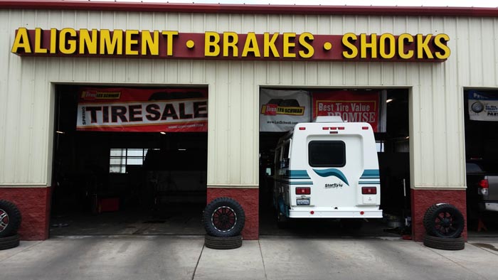
We Got Tire'd
There is nothing more desirable than to reach a campground right around 5. This represents the end of a busy day (of play) for us and we look forward to settling in and relaxing, preferable with a light beverage. Mimi cooks and I play on the computer (division of labor). So it was that after Draper, I scoured
the map and found that we should be able to make Chokecherry Campground right around this time. We had planned to get to another very nice campground we were at last year, but were unsure if it was open, plus we wouldn't get there til after 6. It was a very pleasant campground with an overlook of the lake
that we had mostly to ourselves.
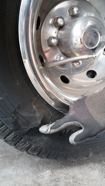
Since we had our pick of sites, I quickly ran around sometimes going the wrong way and around sharp corners in an effort to find the levelest one so not to have to use blocks. On one of those corners we heard a
loud 'boom/pop' like sound. My first thought was that I'd run over a water line and it had burst open. The second was that it was our tire, but I didn't want to think about that one. Sure enough on getting out, I had cut the corner too soon and a sharp rock had punctured the sidewall. The mental wheels
started turning. We had duals, but would the remaining tire hold the weight? What about the flat one, would it be destroyed on the way in to help, if there was even help in the next town? And how far was the town? Well after settling in as best we could and collecting our wits, we found using our GPS that a
Les Schwab was just 7 miles down the road. They had no idea if we could make it, but racking my brain realized from our previous job which included running big rigs, that it should hold the weigh and the flat one should stay on the rim as the only tires that come off trucks are retreads and not whole tires.
In the morning we got on the freeway with trepidation but had no problems making it into Heber City. That Les Schwab dealer was the best sight I'd seen for days. Our mistake cost us $140, but it could have been a lot worse.
Hell Road
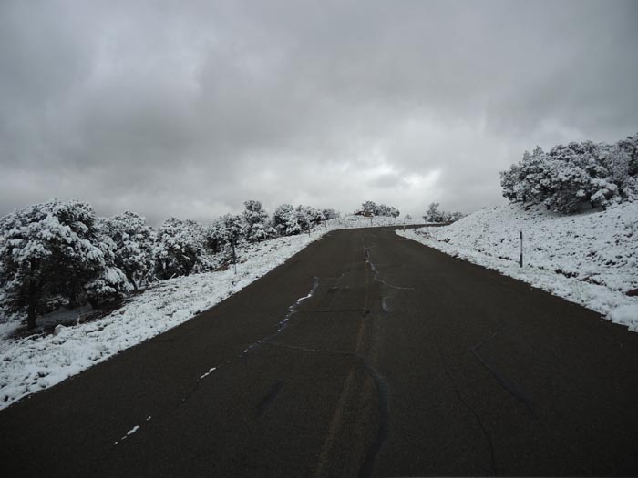
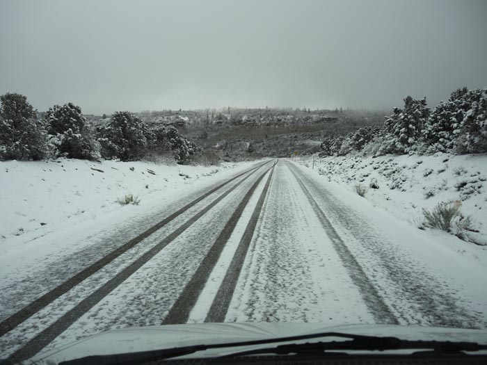
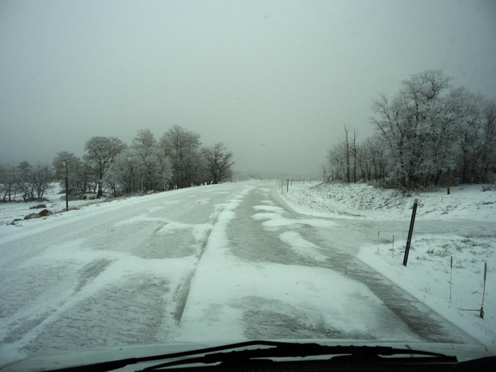
On driving from Canyonlands to Natural Bridges we had to pass through Monticello, which was a good thing as we were low on gas. Just past half the half way point, we saw a Monticello sign on what looked like 'Hell's Draw' road and took it as both Garmin and my maps confirmed it was a viable shortcut which
would save us mileage and time. Up ahead, we could see snow covered peaks that were coming closer when Mimi asked what that thin white line off to the left was going up into the mountains. I looked and said it was the snow covered banks of some animal trail or dirt jeep road. Well, as we got closer, our road
turned off to the left and that was our road up. The good news is that the road was still clear and we should have no problems. I watched as Ms Garmin kept adding up our elevation from 6000 feet to now 7000 and we were still climbing with no indication of how high the pass was. Soon we saw snow on the side of
the road and that slowly grew to cover the road, at first lightly and then more heavily. I still thought we'd be ok as long as our tires could reach the asphalt and get a grip. Besides, we should reach the pass at any time. Well, we climbed to 8000 feet and the clouds grew darker and the temperatures and
visibility plunged. Wind whipped up and the snow grew thicker and harder. I grabbed my camera when suddenly Mimi yelled my name. Apparently while fishing for the camera I jerked the wheel ever so slightly and she felt the rear wheels slip on what was now ice, and we still not at the peak. I was contemplating
slowly trying to turn around when at 9000 feet she said "I think we're starting to go down now!" Sure enough in another half mile we could see the brown valley floor and Monticello in the distance and the road began to clear.